


Navionics Platinum+ NPUS012R - Canada, East & Great Lakes
-
Estimated Delivery:Jun 09 - Jun 13
-
Free Shipping: On all orders over $150

Guarantee safe & secure checkout
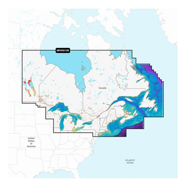
Navionics Platinum+ NPUS012R - Canada, East & Great Lakes
Stories
Stories
Stories
Navionics Platinum+ NPUS012R - Canada, East & Great Lakes
Navionics Platinum+ NPUS012R by Navionics delivers unparalleled marine navigation capabilities for recreational and professional boating enthusiasts. This ultimate marine mapping solution is designed for use with compatible chartplotters, ensuring that every journey across Canada, the East Coast, and the Great Lakes is effortless and precise.
Featuring:
- Advanced Cartography: Benefit from high-resolution charts that provide detailed topographical information and navigational data, enhancing your boating experience.
- Dynamic Tides & Currents: Access real-time tide and current information, crucial for safe and efficient navigation, especially in busy waterways.
- 3D View & Satellite Imagery: Visualize underwater features and shorelines with stunning 3D views and satellite imagery, allowing for better route planning and awareness of your surroundings.
Perfect for weekend warriors, fishing trips, or professional mariners, the Navionics Platinum+ NPUS012R is backed by Navionics' commitment to exceptional quality and precision. With this mapping solution, you can confidently navigate through diverse marine environments, ensuring safety and enjoyment on every voyage.
Enhance your boating adventures today with the Navionics Platinum+ NPUS012R and experience the difference in marine navigation!
Navionics Platinum+ NPUS012R - The Ultimate Marine Mapping Solution
Navionics Platinum+ NPUS012R by Navionics offers unparalleled marine navigation capabilities tailored for both recreational and professional boating enthusiasts. Designed for use with compatible chartplotters, this comprehensive mapping solution delivers the best and most up-to-date cartography for Canadian and Great Lakes waters.
Key Features:
- Detail-Rich Mapping: Access integrated mapping of coastal waters, lakes, and rivers, ensuring you never miss a vital navigational detail.
- Daily Chart Updates: Enjoy constantly enhanced charts with thousands of updates daily through the Navionics chart installer software.
- Dock-to-Dock Route Guidance: Utilize advanced route calculation technology to suggest safe paths through channels and marinas.
Ideal for avid boaters exploring the stunning waterways of Eastern Canada, this product is supported by a one-year subscription for continuous updates, ensuring quality and satisfaction. Elevate your boating experience with the Navionics Platinum+ NPUS012R and navigate with confidence!
Platinum+ NPUS012R - Canada, East & Great Lakes
Get the world’s No. 1 choice in marine mapping - with the best, most up-to-date Navionics+ cartography on a compatible chartplotter.
For offshore or inland waters, this all-in-one solution offers detail-rich integrated mapping of coastal waters, lakes, rivers, and more. Get SonarChart™ 1’ (0.5 meters) HD bathymetry maps and advanced features such as dock-to-dock route guidance technology, live mapping, and Plotter Sync to provide wireless access to daily updates.
The Navionics Chart Installer software also ensures the freshest chart data every time. Navionics dock-to-dock route guidance solutions suggest a path to follow through channels, inlets, marina entrances, and more. Multiple shading options aid in shallow-water navigation and make it easy to highlight a target depth range for the best fishing spots.
Navionics Platinum+™ charts include all the content of Navionics®+ cartography, with integrated offshore and inland mapping, 42,000+ lakes and additional viewing options for relief shading, satellite imagery with SonarChart shading overlay, 3D perspective view, aerial photos, and more.
Chart Code: NPUS012R
Coverage Area
Detailed coverage of coastal and inland waterways of Eastern Canada (except YT and NU). Coverage includes all the Great Lakes, the St Lawrence River, The Maritime Provinces, and the Grand Banks.
Features
All-In-One Map Solution
Access detail-rich mapping of coastal features, lakes, rivers, and more on a wide range of compatible chartplotters. Integrated coastal and inland lake content offers coverage for boaters worldwide.
Daily Chart Updates
Charts are constantly being enhanced with new and amended content — thousands of updates are made every day. The included 1-year subscription gives you access to daily chart updates via the Navionics chart installer software.
Dock-To-Dock Route Guidance
Advanced route guidance technology2 uses boat settings, along with chart data and frequently traveled routes, to calculate a suggested path to follow from dock to dock.
Up to 1’ Contours
For improved fishing and navigation, up to 1' contours provide a clear depiction of bottom structure for fishing charts as well as enhanced detail in swamps, canals, harbors, marinas, and more.
Advanced Map Options
Change the way you view Navionics charts to focus on the details that matter most to users. Highlight shallow areas, adjust contour density, or select a fishing range.
Community Edits
Download community edits for useful local knowledge added by users of the Navionics Boating app, and view the data on a compatible chartplotter.
Plotter Sync
Transfer routes and markers, update charts, and more between your plotter card and mobile app — wirelessly. Users can even activate or renew their cartography subscription and upload sonar logs4.
Sonarchart™ Live Mapping
Create maps on the fly. Watch new 1’ HD bathymetry maps develop in real-time as the boat moves through the water.
High-Resolution Relief Shading
This downloadable shading feature5 combines color and shadow to give users an easy-to-interpret, clearer view of the bottom structure than contour lines alone.
Sonar Imagery
The downloadable sonar imagery feature5 reveals bottom hardness clearly and in a contrasting color, highlighting both subtle and dramatic transition areas on select U.S. lakes.
High-Resolution Satellite Imagery
Downloadable high-resolution satellite imagery5 provides a realistic view of your surroundings — ideal for entering unfamiliar harbors or ports.
Aerial Photography
Crystal-clear aerial and surface photos of ports, marinas, bridges, docks, boat ramps, dams, and navigational landmarks provide a better sense of your surroundings above the waterline.
3D View
Unique 3D views provide additional perspective, both above and below the water’s surface, to highlight key features and aid in situational awareness.
Compatibility:
- Check the compatibility of Navionics+ content and features with the GPS chartplotter being used.
Technical Specifications:
- Format: microSD™/SD™
In the Box:
- microSD™/SD™
1Navionics+ and Navionics Platinum+ cards are not compatible with Garmin chartplotters
2Route guidance is for planning purposes only and does not replace safe navigation operations
3Renewing a subscription, without lapsing, costs up to 50% less than purchasing the same updates and content via a new card or new subscription
4The plotter sync feature requires the use of the Navionics Boating app on your compatible smart device with an active subscription in the same area
5Subscription required; a 1-year subscription (included with the purchase of Navionics Platinum+ mapping solution) lets you access daily chart updates and download additional content or premium features included with your cartography product
*Sold as an Individual
This product may not be returned to the original point of purchase. Please contact the manufacturer directly with any issues or concerns.Shipping Policy
Thank you for choosing Outdoors.Supply. We aim to deliver your gear efficiently and reliably.
Carriers
We ship all orders via UPS Ground or FedEx Ground, depending on availability and destination.
Shipping Rates
- Orders under $150: Flat shipping rate of $15
- Orders $150 and above: Free shipping
Note: A handling fee of $7.50 may apply to certain items. If applicable, it will be clearly stated during checkout.
Order Processing
- Orders placed before 12:00 PM ET (Monday–Friday): Processed the same business day
- Orders placed after 12:00 PM ET or on weekends/holidays: Processed the next business day
Delivery Time
All orders are delivered within 3–7 business days from the date of shipment, depending on your location.
For any questions or concerns about your order, please contact us at [hello@outdoors.supply]. We’re here to help!

Discover more in our FAQ
How long does it take to process an order?
All orders are processed the same business day if placed before 12 PM EST. Orders placed after 12 PM EST are processed the following business day.
Do you ship internationally?
No! Currently we are only supporting shipments to contiguous United States. We do not ship to PO Boxes or Internationally.
What is your return policy?
No Returns
Due to the nature of our products and our commitment to ensuring the highest quality standards, we do not accept any returns under any circumstances.
No Refunds
We do not offer refunds for any reason, including but not limited to:
- Change of mind
- Incorrect size or style ordered
- Delayed shipping
- Product dissatisfaction
Please refer to our Refund Policy
What are your sizing options?
We have a size chart displayed on most products to reflect the sizing as accurate as possible. Please review the size chart and ensure you are leveraging the closest size possible.
Let customers speak for us
Reliable and sturdy—held up well under rough conditions.

Exactly what I needed for my last trip. No complaints!

Solid value for the money. No regrets at all.

Solid value for the money. No regrets at all.

It made a big difference in my outdoor experience.

Reliable and sturdy—held up well under rough conditions.
Performs better than I expected. Worth every penny.
Comfortable and well-designed. Would definitely buy again.
Performs better than I expected. Worth every penny.
I was pleasantly surprised by the durability and performance.

Shipped quickly and arrived in perfect condition.
Exactly what I needed for my last trip. No complaints!
I was pleasantly surprised by the durability and performance.
Exactly what I needed for my last trip. No complaints!

A fantastic product with great features and reliability.
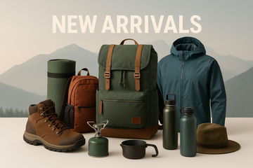
Recently Viewed Products
Why You'll Love Navionics Platinum+ NPUS012R - Canada, East & Great Lakes
Premium Quality
Navionics is known for exceptional quality and attention to detail in every product.
Fast Shipping
Fast and reliable shipping to get your Navionics Platinum+ NPUS012R - Canada, East & Great Lakes to you quickly.
Satisfaction Guarantee
Backed by our comprehensive warranty for complete peace of mind.
Expert Support
Our dedicated support team is here to help with any questions about Navionics Platinum+ NPUS012R - Canada, East & Great Lakes.