


Garmin Navionics+ NSEU054R - Norway, Vestfjorden to Svalbard - Marine Chart
-
Estimated Delivery:Jun 09 - Jun 13
-
Free Shipping: On all orders over $150

Guarantee safe & secure checkout
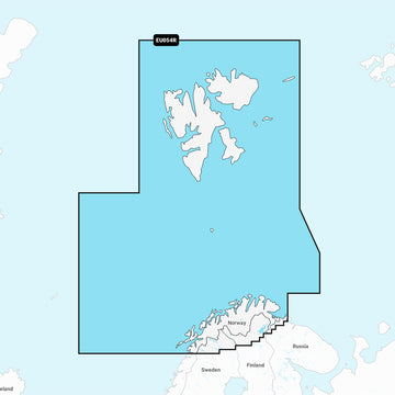
Garmin Navionics+ NSEU054R - Norway, Vestfjorden to Svalbard - Marine Chart
Stories
Stories
Stories
Navionics+ NSEU054R - Norway, Vestfjorden to Svalbard - Marine Chart
Get the world’s No. 1 choice in the marine mapping with the best, most up-to-date Navionics®+ cartography on your compatible chartplotter.
Featuring vibrant colors, a streamlined interface and combined coastal/inland content with a popular Navionics® style color palette, Garmin Navionics+ cartography makes it easy to plot your course. Multiple shading options aid in shallow water navigation and make it easy to highlight a target depth range for the best fishing spots. Fully customizable with various chart layers, overlay combinations and up to 10 color-shaded target depth ranges to scope out the best fishing spots.
When you purchase a new Garmin Navionics+ or Garmin Navionics Vision+ cartography product, a one-year subscription is included.
Chart Code - NSEU054R
Coverage Area:
Detailed coverage of the northern Norway coast from Vestfjorden to Vadso including Tromsø and Narvik. Also includes coverage for Svalbard and approaches.
Features:
- All-in-one Map Solution - Access detail-rich mapping of coastal features, lakes, rivers and more. Integrated Garmin and Navionics® content offers coverage for boaters worldwide.
- Daily Chart Updates - Charts are constantly being enhanced with new and amended content — as many as 5,000 updates are made every day. The one-year included subscription gives you access to daily chart updates via the ActiveCaptain app.
- Auto Guidance+ Technology - Combining the best of Garmin and Navionics automatic routing features, built-in Auto Guidance+ technology1 gives you a suggested dock-to-dock path to follow through channels, inlets, marina entrances and more.
- Depth Range Shading - High-resolution depth range shading lets you select up to 10 color-shaded options and view your designated target depths at a glance.
- Up to 1' Contours - For improved fishing and navigation, up to 1' contours provide a clear depiction of bottom structure for improved fishing charts and enhanced detail in swamps, canals, harbors, marinas and more.
- Shallow Water Shading - To give a clear picture of shallow waters to avoid, this feature allows for shading at a user-defined depth.
- ActiveCaptain Community - Community-sourced content provides useful POIs, such as marinas, anchorages, hazards, businesses and more. Get recommendations from boaters with firsthand experience of the local environment.
Compatibility:
- Check the compatibility of Garmin Navionics+ content and features with your GPS chartplotter.
Technical Specifications:
- Format - MicroSD/SD Card
In the Box:
- SD/MSD Card
1Auto Guidance+ is for planning purposes only and does not replace safe navigation operations
*Sold as an Individual
Shipping Policy
Thank you for choosing Outdoors.Supply. We aim to deliver your gear efficiently and reliably.
Carriers
We ship all orders via UPS Ground or FedEx Ground, depending on availability and destination.
Shipping Rates
- Orders under $150: Flat shipping rate of $15
- Orders $150 and above: Free shipping
Note: A handling fee of $7.50 may apply to certain items. If applicable, it will be clearly stated during checkout.
Order Processing
- Orders placed before 12:00 PM ET (Monday–Friday): Processed the same business day
- Orders placed after 12:00 PM ET or on weekends/holidays: Processed the next business day
Delivery Time
All orders are delivered within 3–7 business days from the date of shipment, depending on your location.
For any questions or concerns about your order, please contact us at [hello@outdoors.supply]. We’re here to help!

Discover more in our FAQ
How long does it take to process an order?
All orders are processed the same business day if placed before 12 PM EST. Orders placed after 12 PM EST are processed the following business day.
Do you ship internationally?
No! Currently we are only supporting shipments to contiguous United States. We do not ship to PO Boxes or Internationally.
What is your return policy?
No Returns
Due to the nature of our products and our commitment to ensuring the highest quality standards, we do not accept any returns under any circumstances.
No Refunds
We do not offer refunds for any reason, including but not limited to:
- Change of mind
- Incorrect size or style ordered
- Delayed shipping
- Product dissatisfaction
Please refer to our Refund Policy
What are your sizing options?
We have a size chart displayed on most products to reflect the sizing as accurate as possible. Please review the size chart and ensure you are leveraging the closest size possible.
Let customers speak for us
Reliable and sturdy—held up well under rough conditions.

Exactly what I needed for my last trip. No complaints!

Solid value for the money. No regrets at all.

Solid value for the money. No regrets at all.

It made a big difference in my outdoor experience.

Reliable and sturdy—held up well under rough conditions.
Performs better than I expected. Worth every penny.
Comfortable and well-designed. Would definitely buy again.
Performs better than I expected. Worth every penny.
I was pleasantly surprised by the durability and performance.

Shipped quickly and arrived in perfect condition.
Exactly what I needed for my last trip. No complaints!
I was pleasantly surprised by the durability and performance.
Exactly what I needed for my last trip. No complaints!

A fantastic product with great features and reliability.
Recently Viewed Products
Why You'll Love Garmin Navionics+ NSEU054R - Norway, Vestfjorden to Svalbard - Marine Chart
Premium Quality
Garmin is known for exceptional quality and attention to detail in every product.
Fast Shipping
Fast and reliable shipping to get your Garmin Navionics+ NSEU054R - Norway, Vestfjorden to Svalbard - Marine Chart to you quickly.
Satisfaction Guarantee
Quality guarantee ensures your satisfaction with every purchase.
Expert Support
Our dedicated support team is here to help with any questions about Garmin Navionics+ NSEU054R - Norway, Vestfjorden to Svalbard - Marine Chart.