


Navionics NAUS001L - U.S. & Coastal Canada - Navionics+
-
Estimated Delivery:Jun 09 - Jun 13
-
Free Shipping: On all orders over $150

Guarantee safe & secure checkout
Navionics NAUS001L - U.S. & Coastal Canada - Navionics+
Stories
Stories
Stories
Navionics NAUS001L - U.S. & Coastal Canada - Navionics+
Navionics NAUS001L by Navionics delivers superior marine mapping technology for avid boaters and fishermen navigating the intricate waters of the U.S. and Coastal Canada. With the advanced Navionics+ cartography, you gain access to the most up-to-date and accurate charts, ensuring your adventures are both safe and enjoyable.
Featuring:
- Comprehensive Coverage: Offers detailed maps for U.S. waters and Coastal Canada, ensuring you have the information you need at your fingertips.
- Advanced Cartography: Enjoy high-resolution sonar charts and satellite imagery that enhance your navigation experience and help you find the best fishing spots.
- Frequent Updates: Get access to daily updates provided by a community of users, keeping your maps current with the latest navigational changes.
Perfect for boaters, fishermen, and outdoor enthusiasts planning trips along the coast, the Navionics NAUS001L is backed by a commitment to quality and precision. Whether you're cruising on a weekend or fishing on a calm afternoon, this marine mapping solution will enhance your experience with its unmatched accuracy and detail.
Don't miss out on the opportunity to navigate with confidence—order your Navionics NAUS001L today and take your marine adventures to the next level!
Navionics NAUS001L - U.S. & Coastal Canada - Navionics+
Navionics NAUS001L by Navionics offers the best in marine mapping technology, tailored for avid boaters and fishermen navigating the intricate waters of the U.S. and Coastal Canada. With Navionics+ cartography, you gain access to the most up-to-date and detailed maps for offshore and inland adventures.
Key Features:
- SonarChart™ HD Bathymetry: Experience innovative 1' (0.5 m) bathymetry maps, enhancing your navigation and fishing experience.
- Dock-to-Dock Route Guidance: Start your journey with suggested paths through channels and marinas, ensuring safe navigation.
- Daily Updates: Enjoy up to 5,000 updates daily, providing you with the freshest and most accurate chart data available.
Ideal for recreational boaters and fishing enthusiasts exploring coastlines, lakes, and rivers, this product is supported by daily updates and real-time mapping, ensuring top-notch quality and satisfaction. Upgrade your navigation experience now with Navionics NAUS001L and never miss a great fishing spot!
NAUS001L - U.S. & Coastal Canada - Navionics+
Get the world’s No. 1 choice in marine mapping - with the best, most up-to-date Navionics+ cartography on your compatible chartplotter.
For offshore or inland waters, this all-in-one solution offers detail-rich integrated mapping of coastal waters, lakes, rivers and more. Get SonarChart™ 1’ (0.5 meter) HD bathymetry maps, advanced features such as dock-to-dock route guidance technology, live mapping and Plotter Sync to provide wireless access to daily updates.
The Navionics Chart Installer software also ensures the freshest chart data every time out. Navionics dock-to-dock route guidance solutions give you a suggested path to follow through channels, inlets, marina entrances and more. Multiple shading options aid in shallow water navigation and make it easy to highlight a target depth range for the best fishing spots.
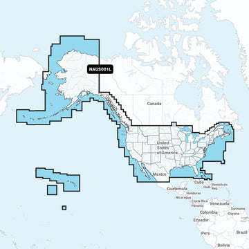
Chart Code - NAUS001L
Coverage Area:
Coverage of the entire U.S. coasts, lakes, rivers and inland waterways, plus Alaska and Hawaii. Canada coverage of coastal British Columbia, the Great Lakes, the St. Lawrence Seaway, New Brunswick and Nova Scotia. Coverage includes Bermuda, the Bahamas, Baja California, the Gulf of California, Johnston Atoll and Palmyra Atoll/Kingman Reef.
Features:
- Nautical Chart – Comprehensive charts are derived from multiple officials, government, and private sources, displayed in a familiar look and feel
- SonarChart HD Bathymetry - Innovative 1' (0.5 m) bathymetry charts are created by using Navionics proprietary systems that augment existing content with sonar data contributed by the boating community
- Community Edits - Get useful local knowledge from edits made by users of the Navionics Boating app on your compatible smart device.
- Daily Updates - Up to 5,000 daily updates to our charts give you the most accurate, most current Navionics data available.1
- Dock-to-dock Route Guidance2 - Start your trip with a suggested path.
- SonarChart Live Mapping - Watch new HD depth maps develop in real-time as your boat moves through the water.
- Advanced Map Options - Customize your view to focus on the details that matter most
- Plotter Sync1 - Transfer routes and markers, update chart layers, and more - between your compatible chartplotter and the Boating app.
Compatibility:
- Check the compatibility of Navionics+ content and features with your GPS chartplotter.
Technical Specifications:
- Format - SD/MSD Card
In the Box:
- SD/MSD Card
1Subscription not required for SonarChart Live mapping feature on some chartplotter models; requires latest chartplotter firmware release.
2Dock-to-dock Route Guidance is for planning purposes only and does not replace safe navigation operations.
*Navionics+ and Platinum+ cards are not compatible with Garmin chartplotters.
*Sold as an Individual
This product may not be returned to the original point of purchase. Please contact the manufacturer directly with any issues or concerns.Shipping Policy
Thank you for choosing Outdoors.Supply. We aim to deliver your gear efficiently and reliably.
Carriers
We ship all orders via UPS Ground or FedEx Ground, depending on availability and destination.
Shipping Rates
- Orders under $150: Flat shipping rate of $15
- Orders $150 and above: Free shipping
Note: A handling fee of $7.50 may apply to certain items. If applicable, it will be clearly stated during checkout.
Order Processing
- Orders placed before 12:00 PM ET (Monday–Friday): Processed the same business day
- Orders placed after 12:00 PM ET or on weekends/holidays: Processed the next business day
Delivery Time
All orders are delivered within 3–7 business days from the date of shipment, depending on your location.
For any questions or concerns about your order, please contact us at [hello@outdoors.supply]. We’re here to help!

Discover more in our FAQ
How long does it take to process an order?
All orders are processed the same business day if placed before 12 PM EST. Orders placed after 12 PM EST are processed the following business day.
Do you ship internationally?
No! Currently we are only supporting shipments to contiguous United States. We do not ship to PO Boxes or Internationally.
What is your return policy?
No Returns
Due to the nature of our products and our commitment to ensuring the highest quality standards, we do not accept any returns under any circumstances.
No Refunds
We do not offer refunds for any reason, including but not limited to:
- Change of mind
- Incorrect size or style ordered
- Delayed shipping
- Product dissatisfaction
Please refer to our Refund Policy
What are your sizing options?
We have a size chart displayed on most products to reflect the sizing as accurate as possible. Please review the size chart and ensure you are leveraging the closest size possible.
Let customers speak for us
Reliable and sturdy—held up well under rough conditions.

Exactly what I needed for my last trip. No complaints!

Solid value for the money. No regrets at all.

Solid value for the money. No regrets at all.

It made a big difference in my outdoor experience.

Reliable and sturdy—held up well under rough conditions.
Performs better than I expected. Worth every penny.
Comfortable and well-designed. Would definitely buy again.
Performs better than I expected. Worth every penny.
I was pleasantly surprised by the durability and performance.

Shipped quickly and arrived in perfect condition.
Exactly what I needed for my last trip. No complaints!
I was pleasantly surprised by the durability and performance.
Exactly what I needed for my last trip. No complaints!

A fantastic product with great features and reliability.
Recently Viewed Products
Why You'll Love Navionics NAUS001L - U.S. & Coastal Canada - Navionics+
Premium Quality
Navionics is known for exceptional quality and attention to detail in every product.
Fast Shipping
Fast and reliable shipping to get your Navionics NAUS001L - U.S. & Coastal Canada - Navionics+ to you quickly.
Satisfaction Guarantee
Backed by our comprehensive warranty for complete peace of mind.
Expert Support
Our dedicated support team is here to help with any questions about Navionics NAUS001L - U.S. & Coastal Canada - Navionics+.