


Garmin Navionics+™ NSSA010R Central America & Caribbean
-
Estimated Delivery:Oct 16 - Oct 20
-
Free Shipping: On all orders over $150

Guarantee safe & secure checkout
Garmin Navionics+™ NSSA010R Central America & Caribbean
Stories
Stories
Stories
Garmin Navionics+™ NSSA010R Central America & Caribbean
Garmin Navionics+™ NSSA010R delivers unparalleled cartography for effortless navigation in Central America and the Caribbean. This essential tool combines vibrant colors and a streamlined interface, making it the preferred choice for both leisure and professional mariners.
Featuring:
- Vibrant Color Palette: The Navionics® style color palette enhances visibility and helps you plot courses with ease.
- Coastal & Inland Content: Comprehensive mapping that covers both coastal and inland areas, ensuring you have the information you need wherever you navigate.
- microSD™/SD Compatibility: Easy installation and compatibility with various devices ensure you can update your maps effortlessly and keep them current.
Perfect for boaters, fishermen, and outdoor enthusiasts navigating the beautiful waters of Central America and the Caribbean, this product is backed by Garmin's renowned quality and support. Upgrade your marine mapping experience with Garmin Navionics+™ and ensure smooth sailing on every adventure.
Navionics+™ NSSA010R Central America & Caribbean
Featuring vibrant colors, a streamlined interface, and combined coastal/inland content with a popular Navionics® style color palette, Garmin Navionics+ cartography makes it easy to plot courses with the world’s No. 1 name in marine mapping.
- microSD™/SD™ format
- Navigate with the best offshore and inland lake coverage for a Garmin chartplotter
- Customize the view with various chart layers and overlay combinations
- With the included one-year subscription, access daily updates via the ActiveCaptain® smart-device app
- Auto Guidance+™ technology2 lets users navigate with suggested dock-to-dock routings
- Select up to 10 color-shaded target depth ranges to scope out the best fishing spots
- Save money by renewing the subscription — and continue accessing daily updates plus new content downloads
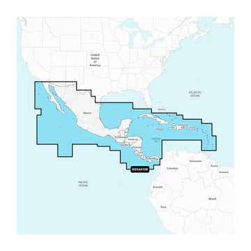
Coverage
Detailed coverage of the west coast of Mexico from Tijuana to Panama. Including the Panama Canal in its entirety. East Coast coverage from Panama to Brownsville, TX. Also includes detailed Caribbean coverage of the Far Bahamas, Turks & Caicos, Cuba, Jamaica, the Caymans, Haiti, the Dominican Republic, Puerto Rico, and the Lesser Antilles to Grenada.
All-In-One Map Solution for Garmin Chartplotters
Access detail-rich mapping of coastal features, lakes, rivers, and more. Integrated Garmin and Navionics® content offers coverage for boaters worldwide.
Daily Chart Updates
Charts are constantly being enhanced with new and amended content — as many as 5,000 updates are made every day. The one-year subscription includes access to daily chart updates via the ActiveCaptain app.
Auto Guidance+ Technology
Combining the best of Garmin and Navionics automatic routing features, built-in Auto Guidance+ technology2 gives users a suggested dock-to-dock path to follow through channels, inlets, marina entrances, and more.
Depth Range Shading
High-resolution depth range shading lets users select up to 10 color-shaded options and view the designated target depths at a glance.
Up to 1’ Contours
For improved fishing and navigation, up to 1' contours provide a clear depiction of bottom structure for improved fishing charts and enhanced detail in swamps, canals, harbors, marinas, and more.
Shallow Water Shading
To give a clear picture of shallow waters to avoid, this feature allows for shading at a user-defined depth.
Raster Cartography
NOAA raster cartography3 is available for some U.S. waters as a free downloadable feature via the ActiveCaptain app to provide paper chart-like views on a plotter.
ActiveCaptain Community
Community-sourced content provides useful POIs, such as marinas, anchorages, hazards, businesses, and more. Get recommendations from boaters with firsthand experience of the local environment.
1Auto Guidance+ is for planning purposes only and does not replace safe navigation operations
2Raster cartography cannot be viewed on echoMAP™ CHIRP and ECHOMAP™ Plus combos but can be viewed on mobile devices via the ActiveCaptain mobile app
3Subscription required; a one-year subscription, which is included with the purchase of the Navionics Vision+ mapping solution, lets users access daily chart updates and download additional content or premium features included with the cartography product
Shipping Policy
Thank you for choosing Outdoors.Supply. We aim to deliver your gear efficiently and reliably.
Carriers
We ship all orders via UPS Ground or FedEx Ground, depending on availability and destination.
Shipping Rates
- Orders under $150: Flat shipping rate of $15
- Orders $150 and above: Free shipping
Note: A handling fee of $7.50 may apply to certain items. If applicable, it will be clearly stated during checkout.
Order Processing
- Orders placed before 12:00 PM ET (Monday–Friday): Processed the same business day
- Orders placed after 12:00 PM ET or on weekends/holidays: Processed the next business day
Delivery Time
All orders are delivered within 3–7 business days from the date of shipment, depending on your location.
For any questions or concerns about your order, please contact us at [hello@outdoors.supply]. We’re here to help!

Discover more in our FAQ
How long does it take to process an order?
All orders are processed the same business day if placed before 12 PM EST. Orders placed after 12 PM EST are processed the following business day.
Do you ship internationally?
No! Currently we are only supporting shipments to contiguous United States. We do not ship to PO Boxes or Internationally.
What is your return policy?
No Returns
Due to the nature of our products and our commitment to ensuring the highest quality standards, we do not accept any returns under any circumstances.
No Refunds
We do not offer refunds for any reason, including but not limited to:
- Change of mind
- Incorrect size or style ordered
- Delayed shipping
- Product dissatisfaction
Please refer to our Refund Policy
What are your sizing options?
We have a size chart displayed on most products to reflect the sizing as accurate as possible. Please review the size chart and ensure you are leveraging the closest size possible.
Let customers speak for us
Reliable and sturdy—held up well under rough conditions.

Exactly what I needed for my last trip. No complaints!

Solid value for the money. No regrets at all.

Solid value for the money. No regrets at all.

It made a big difference in my outdoor experience.

Reliable and sturdy—held up well under rough conditions.
Performs better than I expected. Worth every penny.
Comfortable and well-designed. Would definitely buy again.
Performs better than I expected. Worth every penny.
I was pleasantly surprised by the durability and performance.

Shipped quickly and arrived in perfect condition.
Exactly what I needed for my last trip. No complaints!
I was pleasantly surprised by the durability and performance.
Exactly what I needed for my last trip. No complaints!

A fantastic product with great features and reliability.
Recently Viewed Products
Why You'll Love Garmin Navionics+™ NSSA010R Central America & Caribbean
Premium Quality
Garmin is known for exceptional quality and attention to detail in every product.
Fast Shipping
Fast and reliable shipping to get your Garmin Navionics+™ NSSA010R Central America & Caribbean to you quickly.
Satisfaction Guarantee
Backed by our comprehensive warranty for complete peace of mind.
Expert Support
Our dedicated support team is here to help with any questions about Garmin Navionics+™ NSSA010R Central America & Caribbean.