


Garmin BlueChart® g3 Vision® HD - VUS009R - Jacksonville - Key West - microSD™/SD™
-
Estimated Delivery:Oct 16 - Oct 20
-
Free Shipping: On all orders over $150

Guarantee safe & secure checkout
Garmin BlueChart® g3 Vision® HD - VUS009R - Jacksonville - Key West - microSD™/SD™
Stories
Stories
Stories
Garmin BlueChart® g3 Vision® HD - VUS009R - Jacksonville - Key West - microSD™/SD™
Garmin BlueChart® g3 Vision® HD - VUS009R delivers unparalleled navigation accuracy for boating enthusiasts and maritime adventurers. This state-of-the-art cartography solution covers the stunning waters from Darien, GA to Key West, FL, ensuring you sail with confidence through every journey.
Featuring:
- Detailed Coverage: Offers comprehensive data from the Explorer Charts of the Bahamas, including the entire St. John's River and Lake Okeechobee.
- Enhanced Vision: Displays high-definition imagery, ensuring you have the clearest view of your routes and surroundings.
- MicroSD™/SD™ Compatibility: Easily integrates with compatible devices, providing a hassle-free navigation experience.
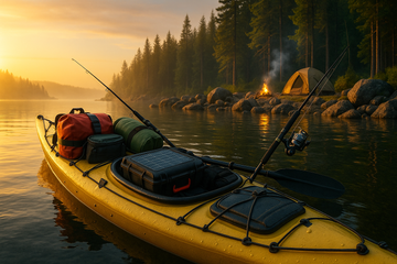
Perfect for both novice and experienced boaters, the Garmin BlueChart® g3 Vision® HD is backed by Garmin’s commitment to quality, offering reliable performance for all your nautical adventures. Whether you’re fishing in remote areas or cruising along the coast, this product ensures you have the essential tools for safe and enjoyable travels.
Start your journey with confidence and precision today! This product comes with a 2-year warranty, affirming Garmin's dedication to your satisfaction.

BlueChart® g3 Vision® HD - VUS009R - Jacksonville - Key West - microSD™/SD™
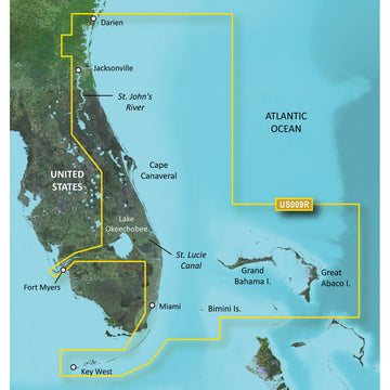
Coverage:
Featuring data from the Explorer Charts of the Bahamas. Darien, GA to Key West, FL including the entire St. John's River, the St. Lucie Canal, Lake Okeechobee, with coverage over to Ft. Myers. Also includes detailed coverage of Bimini, the Abacos and Grand Bahama Island.
Premier Coastal Navigation Charts
- Provides industry-leading coverage, clarity and detail with updated coastal charts that feature integrated Garmin and Navionics® data
- Auto Guidance¹ technology uses your desired depth and overhead clearance to calculate routes and show a suggested path to follow
- High-resolution relief shading combines color and shadow to give you an easy-to-interpret, clearer view of bottom structure than contour lines alone
- Depth Range Shading provides up to 10 depth ranges, enabling you to view your target depth at a glance
- Up to 1’ contours provide a more accurate depiction of the bottom structure for improved fishing charts and navigation in swamps, canals and marinas
Experience unparalleled coverage and brilliant detail on the water. BlueChart g3 Vision coastal charts provide industry-leading coverage, clarity and detail with integrated Garmin and Navionics data, Auto Guidance technology and high-resolution relief shading..
Auto Guidance Technology
The Auto Guidance feature¹ uses your desired depth and overhead clearance to calculate a route and a suggested path to follow.
High-resolution Relief Shading Feature
High-resolution relief shading combines color and shadow to give you an easy-to-interpret, clearer view of bottom structure than contour lines alone.
Up to 1’ Contours
The closer the contour lines, the more accurate the depiction of the bottom structure for improved fishing charts and navigation in swamps, canals and marinas.
NOAA Raster Cartography
If you prefer your display to have the look of paper charts, NOAA raster cartography2 is available as a free downloadable feature via the ActiveCaptain® app.
Depth Range Shading
This feature provides up to 10 depth ranges, enabling you to view your target depth at a glance.
Shallow Water Shading
This feature allows you to use shading to designate the shallow water depths you need to avoid.
High-resolution Satellite Imagery
These detailed images of ports, marinas, bridges and navigational landmarks help provide you with superior situational awareness.
Unique 3-D Views
MarinerEye and FishEye views provide additional perspective both above and below the water line.
¹Auto Guidance is for planning purposes only and does not replace safe navigation operations
²Raster cartography cannot be viewed on echoMAP CHIRP and ECHOMAP Plus combos but can be viewed on mobile devices via the ActiveCaptain mobile app
WARNING: This product can expose you to chemicals which are known to the State of California to cause cancer, birth defects or other reproductive harm. For more information go to P65Warnings.ca.gov.
Shipping Policy
Thank you for choosing Outdoors.Supply. We aim to deliver your gear efficiently and reliably.
Carriers
We ship all orders via UPS Ground or FedEx Ground, depending on availability and destination.
Shipping Rates
- Orders under $150: Flat shipping rate of $15
- Orders $150 and above: Free shipping
Note: A handling fee of $7.50 may apply to certain items. If applicable, it will be clearly stated during checkout.
Order Processing
- Orders placed before 12:00 PM ET (Monday–Friday): Processed the same business day
- Orders placed after 12:00 PM ET or on weekends/holidays: Processed the next business day
Delivery Time
All orders are delivered within 3–7 business days from the date of shipment, depending on your location.
For any questions or concerns about your order, please contact us at [hello@outdoors.supply]. We’re here to help!

Discover more in our FAQ
How long does it take to process an order?
All orders are processed the same business day if placed before 12 PM EST. Orders placed after 12 PM EST are processed the following business day.
Do you ship internationally?
No! Currently we are only supporting shipments to contiguous United States. We do not ship to PO Boxes or Internationally.
What is your return policy?
No Returns
Due to the nature of our products and our commitment to ensuring the highest quality standards, we do not accept any returns under any circumstances.
No Refunds
We do not offer refunds for any reason, including but not limited to:
- Change of mind
- Incorrect size or style ordered
- Delayed shipping
- Product dissatisfaction
Please refer to our Refund Policy
What are your sizing options?
We have a size chart displayed on most products to reflect the sizing as accurate as possible. Please review the size chart and ensure you are leveraging the closest size possible.
Let customers speak for us
Reliable and sturdy—held up well under rough conditions.

Exactly what I needed for my last trip. No complaints!

Solid value for the money. No regrets at all.

Solid value for the money. No regrets at all.

It made a big difference in my outdoor experience.

Reliable and sturdy—held up well under rough conditions.
Performs better than I expected. Worth every penny.
Comfortable and well-designed. Would definitely buy again.
Performs better than I expected. Worth every penny.
I was pleasantly surprised by the durability and performance.

Shipped quickly and arrived in perfect condition.
Exactly what I needed for my last trip. No complaints!
I was pleasantly surprised by the durability and performance.
Exactly what I needed for my last trip. No complaints!

A fantastic product with great features and reliability.
Recently Viewed Products
Why You'll Love Garmin BlueChart® g3 Vision® HD - VUS009R - Jacksonville - Key West - microSD™/SD™
Premium Quality
Garmin is known for exceptional quality and attention to detail in every product.
Fast Shipping
Fast and reliable shipping to get your Garmin BlueChart® g3 Vision® HD - VUS009R - Jacksonville - Key West - microSD™/SD™ to you quickly.
Satisfaction Guarantee
Backed by our comprehensive warranty for complete peace of mind.
Expert Support
Our dedicated support team is here to help with any questions about Garmin BlueChart® g3 Vision® HD - VUS009R - Jacksonville - Key West - microSD™/SD™.