


Garmin BlueChart® g3 HD - HXUS604x - US All & Canadian West - microSD™/SD™
-
Estimated Delivery:Jun 09 - Jun 13
-
Free Shipping: On all orders over $150

Guarantee safe & secure checkout
Garmin BlueChart® g3 HD - HXUS604x - US All & Canadian West - microSD™/SD™
Stories
Stories
Stories
Garmin BlueChart® g3 HD - HXUS604x - The Ultimate Nautical Navigation Solution
Garmin BlueChart® g3 HD - HXUS604x delivers unparalleled coastal navigation coverage for both recreational and professional mariners. This premium microSD™/SD™ card provides detailed mapping of the U.S. and Canadian West coasts, making it an essential tool for boaters, fishermen, and maritime enthusiasts.
Featuring:
- Comprehensive Coverage: Offers extensive coastal charting from Key West, FL, to the Canadian border on the East Coast, and from Puget Sound to the Mexican border on the West Coast, including Alaska, Hawaii, and major inland rivers.
- Enhanced Detail: Utilizes advanced Garmin cartography technology to deliver high-definition charts, providing crucial information for safe navigation.
- User-Friendly Installation: Easy plug-and-play functionality for quick setup on compatible Garmin devices, ensuring immediate access to essential navigation data.
Perfect for boaters, fishermen, and maritime professionals navigating coastal waters, this product is backed by Garmin's commitment to quality and innovation. With the Garmin BlueChart® g3 HD, you can trust in accurate and reliable navigation, ensuring peace of mind while exploring.
Experience the difference with the Garmin BlueChart® g3 HD - HXUS604x, your trusted companion on the water. Order now and take the first step towards safer and more efficient voyages!

BlueChart® g3 HD - HXUS604x - US All & Canadian West - microSD™/SD™
Coverage
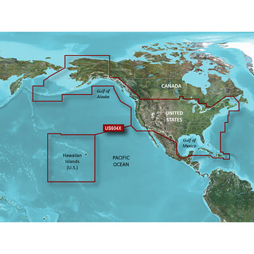
Provides detailed coastal coverage of the U.S., including the East Coast from Key West, FL, to the Canadian border, and the West Coast from Puget Sound to the Mexican border; Alaska; Hawaii and major inland rivers; the U.S. Gulf Coast to the Mexican border and the Mexican Gulf Coast to the Yucatan. Canadian coverage includes the entire St. Lawrence Seaway, Nova Scotia and New Brunswick. The Great Lakes are covered in their entirety as are the Lake of the Woods. Coverage includes Prince Edward Island, Anticosti Island, Vancouver Island, including the Inside and Outside Passages, the Aleutian and Channel Islands, the Bahamas, the Turks and Caicos Islands, Cozumel, Cuba, Hispaniola, Puerto Rico and the U.S. Virgin Islands.
Unparalleled Coastal Chart Coverage
- Provides industry-leading coverage, clarity and detail with updated coastal charts that feature integrated Garmin and Navionics® data
- Auto Guidance¹ technology calculates a route using your desired depth and overhead clearance and provides a suggested path to follow
- Includes Depth Range Shading for up to 10 depth ranges, enabling you to view your target depth at a glance
- Up to 1’ contours provide a more accurate depiction of the bottom structure for improved fishing charts and navigation in swamps, canals and marinas
- NOAA raster cartography² is available as a free downloadable feature via the ActiveCaptain® app
BlueChart g3 coastal charts provide industry-leading coverage, clarity and detail with integrated Garmin and Navionics data. Also included is Auto Guidance¹ technology, which uses your desired depth and overhead clearance to calculate routes and provide a suggested path to follow — overlaid onto your chart. NOAA raster cartography is also available as a free downloadable feature via the ActiveCaptain app. It gives your chartplotter paper chartlike views of NOAA-surveyed areas in which individual points of interest are labeled with corresponding longitude and latitude information. Worldwide coverage is available by regions as accessory cards or via download; each region is sold separately.
Auto Guidance Technology
The Auto Guidance feature¹ calculates a suggested route using your desired depth and overhead clearance.
Depth Range Shading
This feature displays high-resolution Depth Range Shading for up to 10 depth ranges so you can view your designated target depth.
Detailed Contours
BlueChart g3 features up to 1’ contours, which provide a more accurate depiction of the bottom structure for improved fishing charts and navigation in swamps, canals and marinas.
Shallow Water Shading
To aid in navigation, Shallow Water Shading allows map shading at a user-defined depth to give a clear picture of shallow waters to avoid.
NOAA Raster Cartography
This feature gives your chartplotter paper chartlike views of NOAA-surveyed areas in which points of interest are labeled with corresponding longitude and latitude information.
¹Auto Guidance is for planning purposes only and does not replace safe navigation operations
²Raster cartography cannot be viewed on echoMAP CHIRP and ECHOMAP Plus combos but can be viewed on mobile devices via the ActiveCaptain mobile app .
WARNING: This product can expose you to chemicals which are known to the State of California to cause cancer, birth defects or other reproductive harm. For more information go to P65Warnings.ca.gov.
Shipping Policy
Thank you for choosing Outdoors.Supply. We aim to deliver your gear efficiently and reliably.
Carriers
We ship all orders via UPS Ground or FedEx Ground, depending on availability and destination.
Shipping Rates
- Orders under $150: Flat shipping rate of $15
- Orders $150 and above: Free shipping
Note: A handling fee of $7.50 may apply to certain items. If applicable, it will be clearly stated during checkout.
Order Processing
- Orders placed before 12:00 PM ET (Monday–Friday): Processed the same business day
- Orders placed after 12:00 PM ET or on weekends/holidays: Processed the next business day
Delivery Time
All orders are delivered within 3–7 business days from the date of shipment, depending on your location.
For any questions or concerns about your order, please contact us at [hello@outdoors.supply]. We’re here to help!

Discover more in our FAQ
How long does it take to process an order?
All orders are processed the same business day if placed before 12 PM EST. Orders placed after 12 PM EST are processed the following business day.
Do you ship internationally?
No! Currently we are only supporting shipments to contiguous United States. We do not ship to PO Boxes or Internationally.
What is your return policy?
No Returns
Due to the nature of our products and our commitment to ensuring the highest quality standards, we do not accept any returns under any circumstances.
No Refunds
We do not offer refunds for any reason, including but not limited to:
- Change of mind
- Incorrect size or style ordered
- Delayed shipping
- Product dissatisfaction
Please refer to our Refund Policy
What are your sizing options?
We have a size chart displayed on most products to reflect the sizing as accurate as possible. Please review the size chart and ensure you are leveraging the closest size possible.
Let customers speak for us
Reliable and sturdy—held up well under rough conditions.

Exactly what I needed for my last trip. No complaints!

Solid value for the money. No regrets at all.

Solid value for the money. No regrets at all.

It made a big difference in my outdoor experience.

Reliable and sturdy—held up well under rough conditions.
Performs better than I expected. Worth every penny.
Comfortable and well-designed. Would definitely buy again.
Performs better than I expected. Worth every penny.
I was pleasantly surprised by the durability and performance.

Shipped quickly and arrived in perfect condition.
Exactly what I needed for my last trip. No complaints!
I was pleasantly surprised by the durability and performance.
Exactly what I needed for my last trip. No complaints!

A fantastic product with great features and reliability.
Recently Viewed Products
Why You'll Love Garmin BlueChart® g3 HD - HXUS604x - US All & Canadian West - microSD™/SD™
Premium Quality
Garmin is known for exceptional quality and attention to detail in every product.
Fast Shipping
Fast and reliable shipping to get your Garmin BlueChart® g3 HD - HXUS604x - US All & Canadian West - microSD™/SD™ to you quickly.
Satisfaction Guarantee
Backed by our comprehensive warranty for complete peace of mind.
Expert Support
Our dedicated support team is here to help with any questions about Garmin BlueChart® g3 HD - HXUS604x - US All & Canadian West - microSD™/SD™.